Trail Walking La Motte - Les Demoiselles 3 - Photo
 Sugg
Sugg

User

© OpenStreetMap contributors
Length
Length
10.2 km
Max alt
Max alt
112 m
Uphill gradient
Uphill gradient
129 m
Km-Effort
Km-Effort  
12 km
Min alt
Min alt
35 m
Downhill gradient
Downhill gradient
129 m
Boucle
Boucle
Yes
Creation date :
2019-03-22 16:59:38.967
Updated on :
2019-03-22 16:59:39.02

(1 Reviews)

Walking
Walking
3h30
Difficulty : Very easy

Scan this QR Code to open this trail in the SityTrail application

FREE GPS app for hiking

Logo SityTrail SityTrail

IGN / Geographical institutes

Download SityTrail from the App Store Download SityTrail from Google Play

Logo SityTrail SityTrail Plus

The world is yours!

Download SityTrail from the App Store Download SityTrail from Google Play Download SityTrail on Huawei AppGallery

About

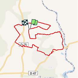
Trail Walking of 10.2 km to be discovered at Provence-Alpes-Côte d'Azur, Var, La Motte. This trail is proposed by Sugg.

Description

Rando du 7 octobre 2015.
Groupe 1 et 2 de Restons en Forme.
Beau temps.
Quelques passages hors piste dans les vignes au sud ouest de le Castelet cote 68/71 et au nord de St-Roman cote 104.Les gués sont traversables malgré les dernières pluies.

Elevation profile

Positioning

Country:
France
Region :
Provence-Alpes-Côte d'Azur
Department/Province :
Var
Municipality :
La Motte
Location:
Unknown
Start:(UTM)
303577 ; 4820451 (32T) N.

Comments

Please log in to post a review or rate the element


par parcours facile


Close
My subscriptions